Publications
Find my publications here.
2025
-
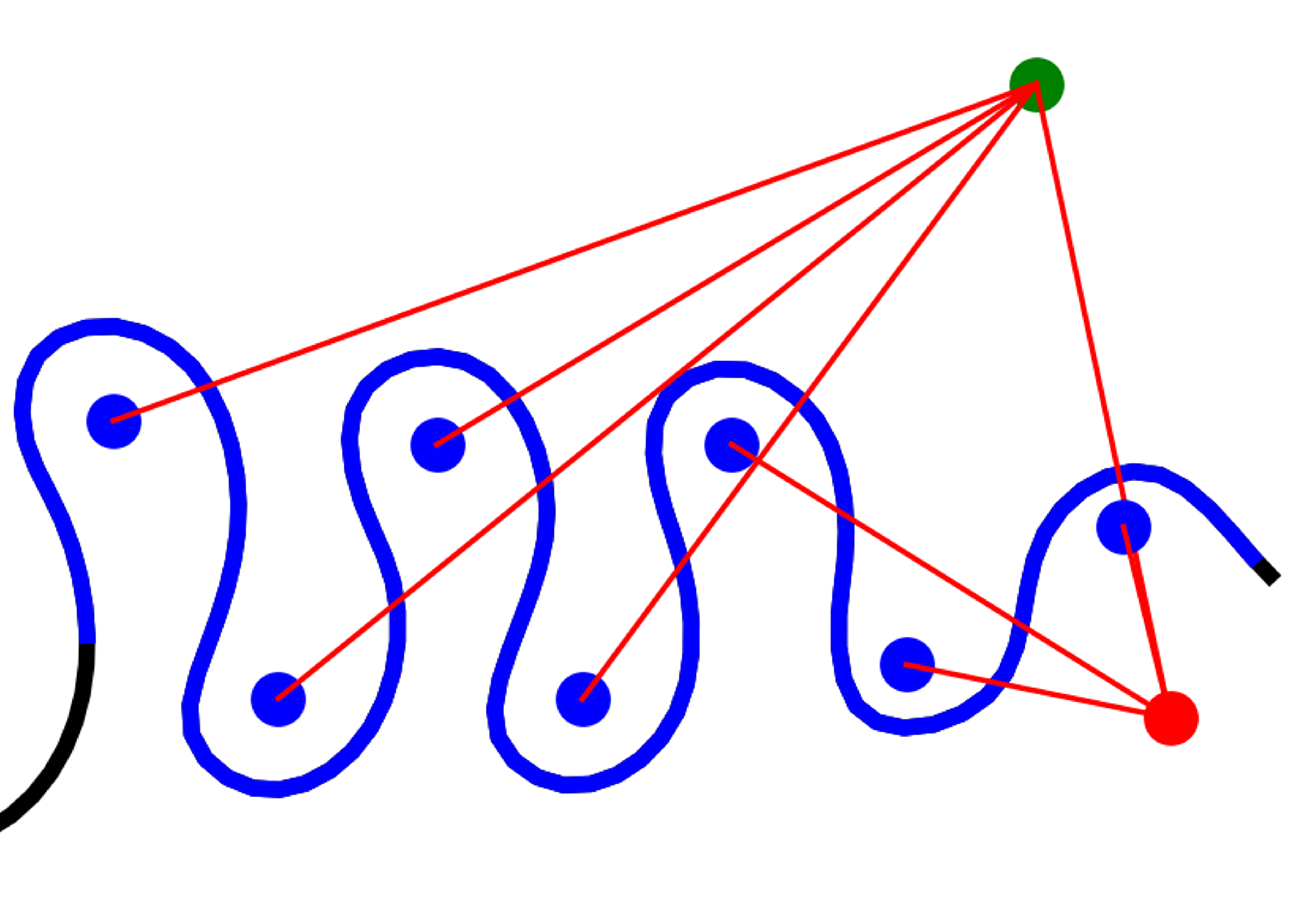 WigglyRivers: A tool to characterize the multiscale nature of meandering channelsDaniel Gonzalez-Duque and Jesus D. Gomez-VelezEnvironmental Modelling & Software, Mar 2025
Channel sinuosity is ubiquitous along river networks, producing complex patterns that encapsulate and influence morphodynamic processes and ecosystem services. Accurately characterizing these patterns is challenging with traditional curvature-based algorithms. Here, we present WigglyRivers, a Python package that builds on existing wavelet-based methods to create an unsupervised meander identification and characterization tool. The package uses planimetric information the user provides or from the USGS’s High-Resolution National Hydrography Dataset to characterize individual reaches or entire river networks. WigglyRivers also includes a supervised river identification tool for manually selecting individual meandering features. Here, we provide examples of idealized river transects and show the capabilities of WigglyRivers. We also use the supervised identification tool to validate the unsupervised identification on river transects across the continental US. WigglyRivers is a tool to understand better the multiscale characteristics of river networks and the link between river geomorphology and river corridor connectivity.
2024
-
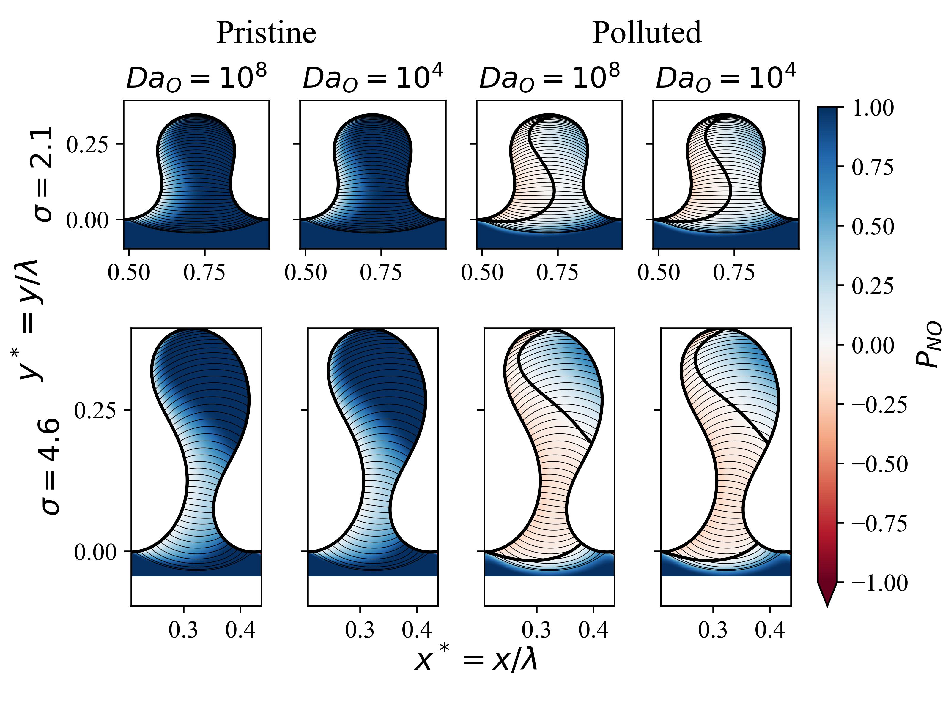 Sinuosity-Driven Hyporheic Exchange: Hydrodynamics and Biogeochemical PotentialsDaniel Gonzalez-Duque, Jesus D. Gomez-Velez, Jay P. Zarnetske, and 2 more authorsWater Resources Research, Mar 2024_eprint: https://onlinelibrary.wiley.com/doi/pdf/10.1029/2023WR036023
Hydrologic exchange processes are critical for ecosystem services along river corridors. Meandering contributes to this exchange by driving channel water, solutes, and energy through the surrounding alluvium, a process called sinuosity-driven hyporheic exchange. This exchange is embedded within and modulated by the regional groundwater flow (RGF), which compresses the hyporheic zone and potentially diminishes its overall impact. Quantifying the role of sinuosity-driven hyporheic exchange at the reach-to-watershed scale requires a mechanistic understanding of the interplay between drivers (meander planform) and modulators (RGF) and its implications for biogeochemical transformations. Here, we use a 2D, vertically integrated numerical model for flow, transport, and reaction to analyze sinuosity-driven hyporheic exchange systematically. Using this model, we propose a dimensionless framework to explore the role of meander planform and RGF in hydrodynamics and how they constrain nitrogen cycling. Our results highlight the importance of meander topology for water flow and age. We demonstrate how the meander neck induces a shielding effect that protects the hyporheic zone against RGF, imposing a physical constraint on biogeochemical transformations. Furthermore, we explore the conditions when a meander acts as a net nitrogen source or sink. This transition in the net biogeochemical potential is described by a handful of dimensionless physical and biogeochemical parameters that can be measured or constrained from literature and remote sensing. This work provides a new physically based model that quantifies sinuosity-driven hyporheic exchange and biogeochemical reactions, a critical step toward their representation in water quality models and the design and assessment of river restoration strategies.
-
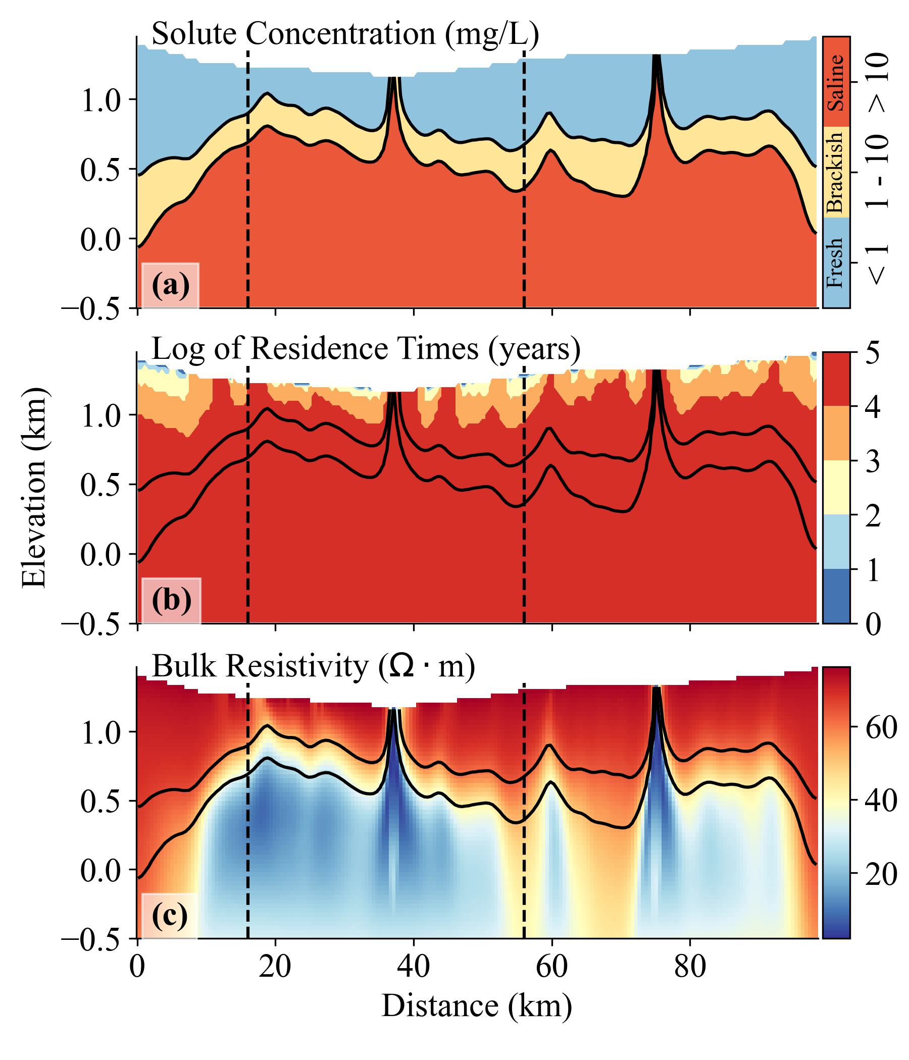 Groundwater Circulation Within the Mountain Block: Combining Flow and Transport Models With Magnetotelluric Observations to Untangle Its Nested NatureDaniel Gonzalez-Duque, J. D. Gomez-Velez, M. A. Person, and 3 more authorsWater Resources Research, Mar 2024_eprint: https://onlinelibrary.wiley.com/doi/pdf/10.1029/2023WR035906
Mountains are vital water sources for humans and ecosystems, continuously replenishing lowland aquifers through surface runoff and mountain recharge. Quantifying these fluxes and their relative importance is essential for sustainable water resource management. However, our mechanistic understanding of the flow and transport processes determining the connection between the mountain block and the basin aquifer remains limited. Traditional conceptualizations assume groundwater circulation within the mountain block is predominantly shallow. This view neglects the role of deep groundwater flowpaths significantly contributing to the water, solute, and energy budgets. Overcoming these limitations requires a holistic characterization of the multiscale nature of groundwater flow along the mountain-to-valley continuum. As a proof-of-concept, we use a coupled groundwater flow and transport model to design a series of numerical experiments that explore the role of geology, topography, and weathering rates in groundwater circulation and their resulting resistivity patterns. Our results show that accumulating solutes near stagnation zones create contrasting electrical resistivity patterns that separate local, intermediate, and regional flow cells, presenting a target for magnetotelluric observations. To demonstrate the sensitivity of magnetotelluric data to features in our resistivity models, we use the MARE2DEM electromagnetic modeling code to perform forward and inverse simulations. This study highlights the potential of magnetotelluric surveys to image the resistivity structure resulting from multiscale groundwater circulation through relatively impervious crystalline basement rocks in mountainous terrains. This capability could change our understanding of the critical zone, offering a holistic perspective that includes deep groundwater circulation and its role in conveying solutes and energy.
2023
- Analysis of Convective Temperature Overturns near the East Rincon Hills Fault Zone using Semi-Analytical ModelsMark Person, William D Stone, Melinda Horne, and 4 more authorsGeothermal Rising, Mar 2023
The Rincon geothermal system (RGS) is one of the more promising intermediate temperature (~150°C) geothermal prospects in New Mexico; one well has a bottom hole temperature of 99°C (SLH-1). This well is located about 50 m east of the East Rincon Hill Fault (ERHF) zone in the Rincon Hills in south-central New Mexico. Brackish (~ 1900 mg/l) geothermal fluids have migrated up the ERHF and flow eastwards in water-table aquifer. This blind geothermal system has no surface expression other than a series of stacked opal deposits. The temperature-depth profile measured in 1993 in SLH-1 was overturned, suggesting transient geothermal behavior. SLH-1 in 1993 had a temperature of 83.9°C just below the water table (depth of 100 m). Below the water table temperatures declined in the borehole to 70.6°C at 176-m depth before increasing. The highest temperature was 99°C at the bottom of the borehole at a depth of 371 m. We remeasured the temperature profile in SLH-1 in September 2018 and found it to be nearly unchanged in the intervening 25 years. The temperature at 100 m in 2018 was slightly warmer compared to 1993 (84.8°C) and was warmer at the minimum at 173 m (73.7°C), but otherwise the two profiles overlap perfectly. This suggests steady-state hydrothermal conditions. As a consequence of these observations, we developed and applied a semi-analytical, steady-state model describing conductive and convective heat transfer resulting from three-dimensional flow groundwater flow. The solution is based on the assumption of fault perpendicular groundwater flow (qh) within an unconfined hot water-table aquifer and regional fault-parallel flow within an underlying cooler confined aquifer (qc). Vertical conductive heat transfer is assumed to dominate above, below, and in between these stacked aquifers. The three-dimensional flow rates needed to produce temperature overturns were evaluated using a sensitivity study. This model produces steady-state temperature overturns similar to the overturn measured in SLH-1 provided that convective heat transfer dominates within both the hot and the cooler aquifers and that qh/qc is about 2.
2022
- Two-tiered reconstruction of Late Pleistocene to Holocene changes in the freezing level height in the largest glacierized areas of the Colombian AndesDaniel Ruiz-Carrascal, Daniel González-Duque, and Isabel Restrepo-CorreaJournal of Mountain Science, Mar 2022
One way of deducing vertical shifts in the altitudinal distribution of Colombian high-altitude páramo environments is by inferring fluctuations in the height of the local freezing level. In our research, we are implementing two complementary approaches to reconstruct Late Pleistocene to Holocene changes in the freezing level height (FLH) in two of the most extensively glacier-covered areas of the northern Andes. We combined remote sensing and field-based geomorphological mapping with time-series reconstruction of changes in the altitude of the 0°C isotherm. Changes in the FLH were based on already-published ∼30 kyr paleo-reconstructions of sea surface temperatures (SSTs) of the eastern tropical Pacific and the western tropical Atlantic, as well as on reconstructed long-term sea level changes and empirical orthogonal functions of present-day (historical) Indo-Pacific and tropical Atlantic SST anomalies. We also analyzed the probability distribution of air-sea temperature differences and the spatial distribution of grid points with SSTs above the minimum threshold necessary to initiate deep convection. We considered available historical near-surface and free air temperature data of ERA-Interim reanalysis products, General Circulation Model (GCM) simulations, weather stations, and (deployed by our group) digital sensors, to assess the normal Environmental Lapse Rates (ELRs) at the regional to local scale. The combined maps of glacial landforms and our reconstructed FLHs provided us with a well-founded inference of potential past glacier advances, narrowing down the coarse resolution of ice margins suggested by previous research efforts. The extent of the areas with temperatures below the freezing point suggested here for the summits of our main study site exceeds in magnitude the corresponding glacier icecaps and front advances proposed by previous studies. Conversely, our average lowest altitudes of the FLH for our comparative site are consistently above the main glacier-front advances previously suggested. Our results indicate that, compared to the maximum upward changes that likely took place over the past ca. observed (present-day) upward shifts of the FLH have occurred at a rate that significantly surpasses our inferred rates. Our study helps fill the gaps in understanding past climatic changes and present trends in the region of interest and provides some insights into analyzing the signals of natural and anthropogenic climate change.